English
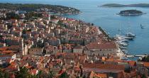
The island of Hvar belongs to the middle-Dalmatian islands. It is situated in the Split-Dalmatia County, in the middle of island group belonging to this county. By the immediate neighbourhood, just north of it is the island Brač, and to the south of it are Šćedro (separated by Šćedro channel), Vis (more towards the southwest), Paklinski Islands, Korčula and the peninsula Pelješac.
Hvar is 72 km long and its widest part is 10.5 km. The total length of its coastline is 254.2 km. Its area is 299.7 km2, which makes it the fourth largest Croatian island. The highest peak is St. Nicholas, 628 m high. The road connecting the City of Hvar at the west coast and Sućuraj at the east side is 84 km long. Hvar is mostly covered by pine woods and vineyards, which give it a very pleasant climate.
There is a wide network of roads at the island. Jelsa, Starigrad and the City of Hvar are connected by a modern road with a tunnel. There is also a network of narrow and bad roads connecting the whole island, from Sućurje to the City of Hvar. The regular ferry lines to the mainland dock at the ports in Stari Grad and Sućuraj. Fast passenger ships connect Jelsa and Hvar with Split. There is a small airport with grassy landing strip for small airplanes.

